The Observations API provides ground-truth data generated by the
Helios analytics. The primary endpoint is the Search
method, which allows users to view all sensor outputs and associated
metadata. Additional methods provide advanced observation
functionality, such as the ability to upload new data for inclusion
in Helios.
Sensor Types
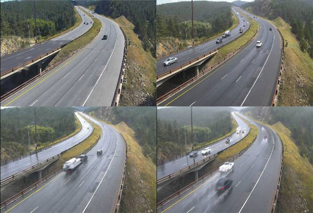
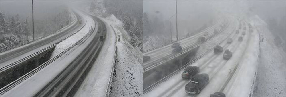
road_weather
The road weather metric provides a full picture of the condition of the road, with metric values indicating if dry, wet, or snow conditions were detected on the road surface.
| Icon | Value | Description |
|---|---|---|

|
10 | Full snow. In these cases, vehicle tracks and bare pavement may be seen in lanes of a multi-lane road, but more than 50% of the road surface is covered. |

|
6 | Partial snow. In these cases, bare pavement is visible in at least one lane. Total snow coverage across the road is approximately 30-50%. |

|
3 | Ponding. The road appears exceptionally wet, with noticeable road spray as vehicles pass through areas of pooling water. |

|
2 | Wet. In these cases, the road is usually shiny and some road spray may be seen behind vehicles traveling at higher speeds. |

|
1 | Moist. Minor amounts of moisture may be seen on the road, but not enough to meet the "wet" criteria. |

|
0 | Dry. No water or snow coverage was detected on the road surface. |

|
-1 | No report due to image quality or content. |
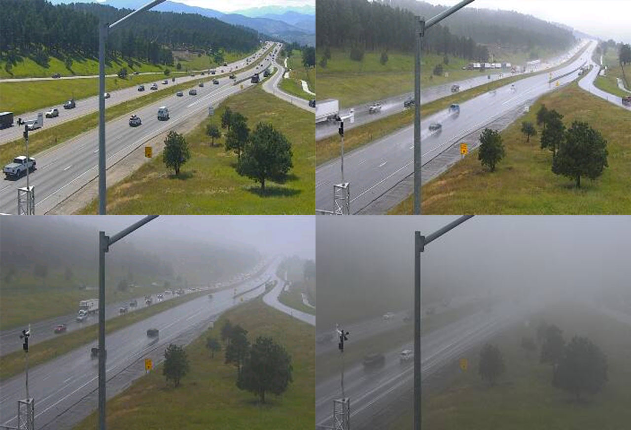
visibility
The visibility metric provides an estimate of the overall scene visibility.
| Icon | Value | Description | Approximate range |
|---|---|---|---|

|
0 | Poor | 0 to 0.3 miles |

|
0.2 | Reduced | 0.3 to 0.7 miles |

|
0.5 | Hazy | 0.7 to 1.5 miles |

|
1 | Good | 1.5+ miles |

|
-1 | No report due to image quality or content |
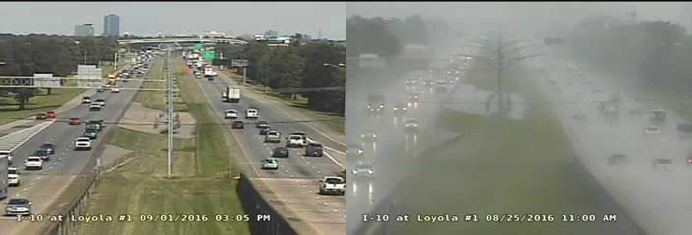
precip
The precip metric indicates the presence of active precipitation.
| Icon | Value | Description |
|---|---|---|

|
1 | Heavy. Indicates sufficient precipitation to impact driving conditions, where roads are significantly wet and visibility has been reduced. |

|
0 | Not heavy. Indicates that heavy precipitation conditions were not detected. |

|
-1 | No report due to image quality or content. |
Search
Return a list of sensor observations matching the provided spatial, text, or metadata filters
Request
GET  https://api.helios.earth/v1/observations  or
POST https://api.helios.earth/v1/observations/_search
Query Parameters
When submitting a search using a GET request, all query parameters are specified as part of the query string. For POST requests,
query parameters can either be submitted using a content type of application/json or x-www-form-urlencoded.
See API Basics for more information.
| bbox | Geospatial bounding box query, specified in GeoJSON format e.g. -180,-90,180,90 |
| polygon | Comma separated coordinate pairs. Each coordinate pair consists of the longitude and
latitude, separated by a space. It is recommended that the first and last coordinate
pairs be equal to properly close the polygon.
e.g. -105 40,-100 36,-110 38,-105 40 |
| lat, lon, radius | Geospatial point radius query. lat and lon are specified in degrees. Radius is optional and can be specified in either meters (no units), kilometers, or miles e.g. 10000 or 10km or 10mi. If no radius is specified, a default value of 10km is assumed. |
| polyline, polyline_precision, polyline_radius |
Geospatial polygon search using the encoded polyline
format used by routing providers. The polyline_precision defaults to a precision of 5, which is used by Google Maps.
For OSRM-based routing providers like Mapbox Directions, use a precision value of 6. The polyline_radius provides a buffer
around the supplied polyline and is specified in kilometers, with a default value of 1.
Note: Polylines can be quite large for complex routes and there is a limit on the size of a query string for GET requests, so it is recommended that you use POST requests to submit searches that include this parameter. |
| sensors |
Sensor types, specified as a nested query parameter. Any of the sensor types listed in the section at the top of this page can be specified. Sensors can either be queried for an exact match or for a range of values by including the min/max nested params. sensors[visibility]=1 sensors[visibility][min]=0&sensors[visibility][max]=1 (beta)
To ensure that any current and previous sensor values are properly interpreted in our
query, we must now nest the current value in a # transition from dry to wet roads sensors[road_weather][data]=3&sensors[road_weather][prev]=0 # transition from dry/wet to partial/fully-covered snow roads sensors[road_weather][data][min]=6&sensors[road_weather][prev][max]=3 |
| time_min, time_max | Observation time (UTC), specified as an ISO 8601 datetime (e.g. 2018-01-01T12:30:00.000Z) or as a time-only string in HH:MM format (e.g 12:30). |
| date_min, date_max | Observation date (UTC) in yyyy-mm-dd format. |
| q | Query string that searches across multiple text fields e.g. q=south |
| country | Country where the observation is located e.g. United States, Canada |
| state | State where the observation is located e.g. California, New York |
| city | City name where the observation is located e.g. Rochester |
| camera_id | Camera ID |
| limit | Limit value for pagination. Defaults to 10. Max value of 100 is allowed. |
| skip | Skip value for pagination. Defaults to 0. Max value of 4000 is allowed. |
| sort | Sort parameter: country, state, city,
time, distance are currently allowed. Note that distance is only
valid for cases when the lat and lon query parameters are also supplied.
|
| sort_dir | Sort direction: asc or desc (default is asc) |
| aggs |
Aggregate and summarize the results set based on the following attributes: Multiple aggregations can be requested using array syntax or by listing them comma-delimited, e.g: aggs[]=state&aggs[]=time aggs=state,time For each requested aggregation, up to ten values and their respective observation counts will be returned. For instance,
if the When performing a To aggregate by the current sensor value, specify each desired sensor using a aggs=sensors.visibility,sensors.road_weather (beta) aggs=sensors.road_weather,sensors.road_weather.prev |
Response
GeoJSON Feature Collection
HTTP 200
application/json

{
  "type": "FeatureCollection",
  "features": [
    {
      "type": "Feature",
      "id": "CADOT-807986_2017-07-21T22:10:00.000Z",
      "geometry": {
        "coordinates": [
          -117.4887542724609,
          34.14170455932617
        ],
        "type": "Point"
      },
      "properties": {
        "camera_id": "CADOT-807986",
        "prev_id": "CADOT-807986_2017-07-21T22:00:00.000Z",
        "description": "Cherry Avenue",
        "city": "Fontana",
        "state": "California",
        "country": "United States",
        "time": "2017-07-21T22:10:00.000Z",
        "sensors": {
          "visibility": {
            "data": 1
          },
          "road_weather": {
            "data": 3,
            "prev": 0
          }
        }
      }
    }
  ],
  "properties": {
    "total": 20,
    "skip": 0,
    "limit": 1,
    "aggs": {
      "state": [
        {"key": "New York", "doc_count": 10},
        {"key": "California", "doc_count": 10}
      ]
    }
  }
}
View example
Tile
Return the current observations in Mapbox Vector Tile format
Request
GET https://api.helios.earth/v1/observations/{z}/{x}/{y}.mvt
Query Parameters
sort_dir |
By default, the features array contained within the tile
will be sorted in ascending time order. Setting this value
to desc will reverse the order, which may be
desired for certain map types.
|
Response
A single vector tile for the specified geographic area (512x512 size). See the Mapbox documentation for more info.
HTTP 200
application/x-protobuf
All
Return all Helios observations (worldwide, all sensor types) for the given time as a single response
Request
GET https://api.helios.earth/v1/observations/_all/:time.json
URL Parameters
time |
UTC time in yyyyddmmThhmmZ format. Data files are provided
"on the tens", e.g. (20180801T1200Z,
20180801T1210Z, etc.) and are generally available 10
minutes after the given time period.
|
Response
HTTP 302
Note: The redirect URL is a signed URL that is valid for 15 minutes. Do not try to re-add any Helios authorization headers when following the redirect or you will not be able to retrieve the data.
Redirect Response
GeoJSON Feature Collection
HTTP 200
application/json

{
  "type": "FeatureCollection",
  "features": [
    {
      "type": "Feature",
      "id": "CADOT-807986_2017-07-21T22:10:00.000Z",
      "geometry": {
        "coordinates": [
          -117.4887542724609,
          34.14170455932617
        ],
        "type": "Point"
      },
      "properties": {
        "image": "https://api.helios.earth/v1/cameras/CADOT-807986/images/CADOT-807986_20170721221005134.jpg",
        "camera_id": "CADOT-807986",
        "description": "Cherry Avenue",
        "city": "Fontana",
        "state": "California",
        "country": "United States",
        "time": "2017-07-21T22:10:00.000Z",
        "sensor.visibility": 1,
        "sensor.road_weather": 3
      }
    }
  ]
}
Show
Return the attributes for a single observation
Request
GET https://api.helios.earth/v1/observations/:id
Response
GeoJSON Feature
HTTP 200
application/json
Preview
Return a preview image for the observation. This API call will attempt to filter out unusable images (e.g. full image text/logos, etc.) and will return the most recent image for the observation time period.
Request
GET https://api.helios.earth/v1/observations/:id/preview
Response
HTTP 302
Note: The redirect URL is a signed URL that is valid for 15 minutes. Do not try to re-add any Helios authorization headers when following the redirect or you will not be able to retrieve the data.
Redirect Response
HTTP 200
image/jpeg