Helios APIs: Cameras (Index)
To return a list of cameras near a given location, we can query the Index method in the Cameras API using a variety of query parameter options, depending on our particular needs.
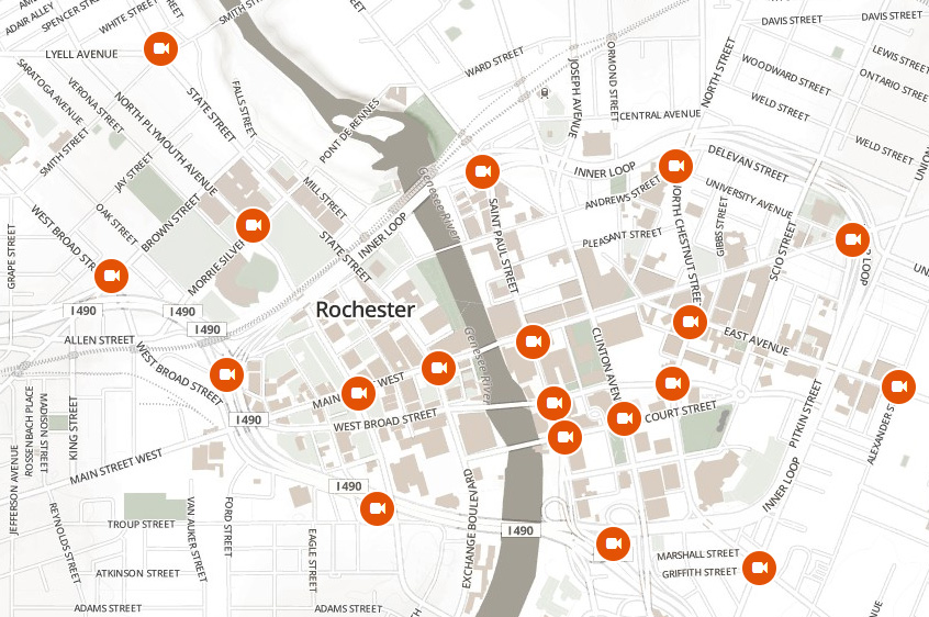
To search for cameras located in downtown Rochester, NY using a bounding box our API request looks like this:
https://api.helios.earth/v1/cameras?bbox=-77.636,43.142,-77.582,43.171
We can also search for cameras in the same area using a latitude, longitude, and radius:
https://api.helios.earth/v1/cameras?lat=43.1563&lon=-77.6088&radius=10000
If we need more precision on the area of interest where we want to search, we can query using a polygon:
https://api.helios.earth/v1/cameras?polygon=-77.6 43.2,-77.5 43.1,-77.7 43.1,-77.6 43.2
All of the cameras in the Helios network contain text attributes describing the location's city, state, region, and country. We can query for cameras in Rochester, NY using these attributes as well:
https://api.helios.earth/v1/cameras?city=rochester&state=new+york
When requesting route information from services like Google Maps or Mapbox Directions, the route is often provided as an encoded polyline. We can used this polyline to perform a polygon search around the given route. To search for cameras along of a stretch of Interstate 490 in Rochester, NY our query looks like this:
https://api.helios.earth/v1/cameras?polyline=}glfG~_iyMfEa`Ppd@gjBr}@c{@_XioFnKk_ANote: polylines are encoded with different precision depending on the provider. For example, Google Maps uses a precision of 5, while services like Mapbox Directions based on the Open Source Routing Machine use a precision of 6. We have used the default value of 5 here. See the API documentation for more information on specifying different values for the polyline precision and radius used to compute the search polygon.